
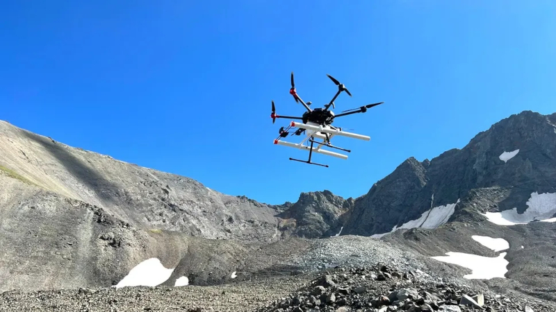
Drones with georadars will be used to search for water sources on Mars
Unmanned aerial vehicles (UAVs) equipped with ground‑penetrating radar can improve site selection for drilling on Mars
Scientists from the University of Arizona, led by Roberto Agilar, demonstrated that a ground‑penetrating radar mounted on a UAV can accurately map subsurface ice masses. As a “test field,” they used icy deposits in Alaska and Wyoming—earth analogs of Martian ice.
What was done
* Publication date – March 24, *Journal of Geophysical Research*.
* Technique – the ground‑penetrating radar on the drone measured the thickness of the debris layer above the ice and the internal structure of the ice masses. This is not possible with orbital radar.
* Experiment – at low altitude over Alaska and Wyoming, scientists mapped ice thickness, recording bedrock fragments within a few feet. Accuracy was verified by field measurements, drilling, and numerical modeling.
> “To decide where to drill on Mars, you need to know whether the target ice lies under one meter of debris or ten,” explained Agilar, graduate student at Arizona’s Lunar‑Planetary Laboratory. “That is exactly what a UAV‑based system can provide.”
Why this matters for Martian missions
* Current orbital radars (e.g., SHARAD on *Mars Reconnaissance Orbiter*) have confirmed the presence of vast ice deposits beneath layers of rock and dust in Mars’ mid latitudes.
* However, they do not determine the precise depth of the ice layer or the thickness of the debris cover—parameters that are critically important for drilling planning.
> “We knew ground‑penetrating radar works, but this was the first time we mounted it on a UAV and tested its practical use,” said Agilar. He emphasized the need to optimize flight altitude, speed, direction relative to ice flow, and radar orientation to obtain reliable ice reflections.
What future reconnaissance will look like
1. Orbital platforms identify large potential areas of interest.
2. UAVs with ground‑penetrating radar refine maps, providing high resolution and precise information on ice depth and debris thickness.
3. Ground missions (rovers, drilling rigs) conduct final drilling and analysis.
This multi‑layered approach reduces risks and increases the likelihood of selecting the most promising sites for research and resource extraction.
Why this matters beyond science
* Water ice is a record of Mars’ past climate conditions.
* For future astronauts it could supply drinking water, oxygen, and even raw material for agriculture.
* Precise site selection also improves the chances of detecting traces of ancient life.
Connection to Ingenuity technology
The idea builds on NASA’s *Ingenuity* helicopter, which proved that powered flight is possible in Mars’ thin atmosphere. UAVs with ground‑penetrating radar fill the gap between current orbital observations and future crewed surface presence.
> “We’re building a bridge between today’s space data and what astronauts will be able to do in the future,” concluded Agilar. “Now we can study ice from the air.”
 Asted Cloud
Comments (0)
Share your thoughts — please be polite and stay on topic.
Log in to comment